|
General |
| |
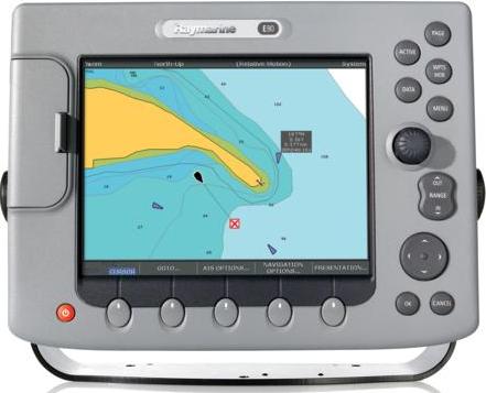
Data Display
Capabilities |
Chartplotter, Fishfinder,
Radar, External Video
(x4), CDI(Course
Deviation Indicator),
and customizable Data
Bar display |
|
| |
Dimensions |
11.14”X 8.27”X 5.27”
(283 x 210 x 133mm) |
|
| |
Display (LCD) size |
8.4" |
|
| |
Display colors |
|
|
| |
Display resolution |
640 x 480 pixels (VGA) |
|
| |
Display type |
Ultra Bright Sunlight
viewable color TFT LCD |
|
| |
Mounting Methods |
Bracket or console
Mounting hardware
included |
|
| |
Operating and non
operating temperature
limits |
14°F to 122°F (-10°C to
50°C) |
|
| |
Power consumption |
20 Watts |
|
| |
Voltage range |
10.7–32 volts (12/24v
nominal) |
|
| |
Waterproofing |
CFR46/IPX6 standards |
|
| |
Weight |
9.2lbs (4.18kg) |
|
| |
Approvals CE - conforms
to FCC - compliant with
|
Essential requirements
of 1995/5/EC,
1989/336/EC. CFR47 Parts
2 & 80 |
|
| |
Mounting |
Either trunnion bracket
or flush mount option
|
|
| |
Humidity limit |
up to 95% at 35°C
non-condensing |
|
| |
Display Windows |
Chart, Radar,
Fishfinder, CDI, Video,
Data, Weather and Engine
Monitor. |
|
| |
Illumination |
Screen and keypad: 0 to
100% in 64 steps
Day/Night Mode |
|
| |
Languages |
The selection available
will vary according to
your location. |
|
| |
System Alarms |
Alarm clock, Anchor,
Arrival, Deep depth,
MOB, Offtrack, Shallow
depth, Temperature,
Timer |
|
| |
Navigation Alarms |
Arrival alarm, offtrack
XTE alarm. |
|
|
Interfaces |
| |
Network Configurations
|
Single, dual or multiple
display configurations.
|
|
| |
SeaTalkhs Network |
Supports 8
devices/displays |
Optional network switch
required |
| |
NMEA 0183 Input |
GLL, GGA, GLC, GTD, VTG,
BWC, BWR, RMA, RMB, RMC,
XTE, VHW, HDG, HDM, HDT,
DBT, DPT, APB, VLW, MWV,
WPL, RTE, DSC and ZDA.
Selectable to 4800, 4800
Navtex, 9600 Navtex or
38,400 AIS |
|
| |
NMEA Output - User
selectable |
APB, BWC, BWR, DBT, DPT,
GGA, GLL, MTW, RMA, RMB,
RMC, RSD, TTM, VLW, VHW,
VTG, WPL, VHF/DSC and
ZDA |
|
| |
SeaTalk Input |
Depth,SOG,COG, Position,
Waypoint number, range/
bearing, TTG, Boat
speed, Time, XTE,
Heading, Wind, data,
Log/Trip, Pilot status,
Temperature, MOB and
cursor position |
|
| |
SeaTalk Output |
Cursor data, guard zone
and navigational data
bridged from NMEA |
|
| |
SeaTalk2/NMEA2000 |
1 port |
Also supports SeaTalkng
(Next Generation data
bus) connectivity.
Adapter cables required
for SeaTalkng and
NMEA2000 |
| |
Video Input |
4 composite video (NTSC
or PAL) inputs (BNC
connector) or 2 S-Video
inputs using an optional
cable |
|
| |
Video Output |
VGA 9 pin sub D
connector |
|
|
Chartplotter |
| |
Waypoints |
1200 waypoints entered
via cursor, lat/lon,
range and bearing from
present position or at
boat’s position. 16
character name can be
assigned. Waypoint
symbols and groups
Additional storage
available on
CompactFlash cards.
|
|
| |
Waypoint Transfer |
Waypoints database via
NMEA and CompactFlash
cards. Software also
available to convert
waypoints to Excel file.
|
|
| |
Man Overboard (MOB Mode)
|
Mark placed with course
line; readout shows
range, bearing, lat/lon
of MOB and time elapsed
since MOB. |
|
| |
Screen functions |
Full, half and quarter
screens available
dependant on function.
Also 3 window page with
2 x 1/4 page windows and
1 x 1/2 page window.
|
|
| |
Cartography |
Navionics Charts on
CompactFlash cards Chart
of the world built in.
|
|
| |
Chart scaling |
1/32nm (if cartographic
detail is available to
4000nm). |
|
| |
Presentation Modes |
Head up, Course up or
North up (selectable
True or Mag-netic).
Relative, Autorange or
True Motion. Screen
offset. Radar or 3D
synchronization. |
|
| |
Routes |
A route plan may contain
up to 50 waypoints. Up
to150 routes can be
stored in the units
internal memory.
Additional storage
available on
CompactFlash cards.
SmartRoute to create a
route from track
history. |
|
| |
Track History |
10 tracks with up to
1000 points in each can
be stored in the units
internal memory. Track
optimization reduces
number of points used or
user selectable time or
distance interval.
Additional storage
available on
CompactFlash cards |
|
| |
Radar/Chart overlay
|
Radar image can be
overlaid on all screen
charts. |
|
| |
Radar/Chart
synchronization |
To synchronize radar
range and chart scale
|
|
| |
3D/Chart synchronization
|
To synchronize 3D and 2D
chart scales and
orientation. |
|
| |
Aerial overlay |
Overlay of aerial
photograph on the chart
|
|
| |
AIS overlay |
Switch AIS symbols
on/off. Display
heading/speed vectors
and ROT. View detailed
AIS data, safety
critical target data,
ALR and SRM messages.
Set up a safe zone.
|
|
| |
Navigation information
|
Own boats position in
lat/lon, XTE, TTG and
SOG/COG selectable.
Bearing and distance to
waypoint. Bearing and
distance to cursor and
ETA. |
|
| |
Cartography |
Navionics Charts on
CompactFlash cards Chart
of the world built in.
|
|
| |
3D Presentation Modes
|
Active motion mode,
planning mode, Adjust
rotation and pitch,
port, starboard, forward
and aft view, multiple
views, Vessel offset
|
|
| |
3D Display |
Declutter, Transducer
cone, Depth scale,
Waypoint name, Adjust
exaggeration, 3D view
locator |
|
|
Radar |
| |
Range Scales (Range
Rings) |
1/8 (1/16)nm to 72 (12)
nm dependant on scanner
Performance limited by
scanner type and
position. |
|
| |
Range Ring Accuracy
|
Better than +/- 1.5% of
the max. range scale in
use, or 22m (72 ft.),
whichever is the
greatest. |
|
| |
Bearing accuracy |
+/- 1° |
|
| |
Variable Range Markers
|
2 x VRM’s, readout nm,
sm, km |
|
| |
Electronic Bearing Lines
|
2 x EBL’s, floating if
required, resolution 1°
|
|
| |
Bearing scale |
360° graduated at 10°
intervals 2° small ticks
10° large ticks |
|
| |
Minimum range |
23m (25 yds) |
|
| |
Range Discrimination
|
23m (25 yds) |
|
| |
Presentation Modes |
Head up, Course up or
North up (selectable
True or Mag-netic)
Relative or True Motion
|
|
| |
Scanner Control |
Interference rejection,
standby/transmit modes,
pulse selection, Tune,
Rain, FTC and Sea
controls, with selection
of manual or automatic
control of gain, sea
clutter and tune (Auto
GST) |
|
| |
Compass Input |
NMEA 0183 (required for
fast heading data,
suitable for MARPA), or
SeaTalk |
|
| |
Waypoint Display |
Create waypoints and
target waypoint
displayed with User
control of symbols and
groups |
|
| |
MARPA |
Manual acquisition of 10
targets, automatic
tracking, dangerous
target alarms, safe
zone, target history,
true or rela-tive
vectors, CPA graphics
and indication of target
speed/ course, bearing/
range, CPA and TCPA.
|
|
| |
Guard Zone Alarm |
2 guard zones,
selectable sensitivity
level, audible alarm
|
|
| |
Automatic Tuning |
Auto control of gain,
sea clutter and tune.
|
|
| |
Off Center function
|
In Relative Motion, 1/3
or |
|
| |
Wakes |
10s, 30s, 1 min, 5 min,
10 min, OFF |
|
| |
Target Expansion |
Operator selectable with
2 levels available, OFF
|
|
| |
Timed TX |
Rotation periods: 10, 20
or 30 scans Repetition
periods: 3, 5, 10 or 15
minutes |
|
| |
AIS overlay |
Switch AIS symbols
on/off. Display
heading/speed vectors
and ROT. View detailed
AIS data, safety
critical target data,
ALR and SRM messages.
Set up a safe zone.
|
|
|
Fishfinder |
| |
Transducer |
Transom-mount, in-hull
or thru-hull options |
|
| |
Receiver Type |
Patented Raymarine HD
Digital receiver
technology |
|
| |
Power output |
Dependant on Digital
Sounder Module |
|
| |
Frequency |
Dependant on Digital
Sounder Module |
|
| |
Alarms |
Fish alarm, fish alarm
depth, shallow and deep
fish limit |
|
| |
A-Scope Display |
Displays Sonar Returns
in real time |
|
| |
Bottom Coverage Display |
Shows the diameter of
the transducer beam
where it meets the
bottom. |
|
| |
Bottom Lock |
Displays echoes directly
above the bottom. |
|
| |
Range markers |
Easily see how far the
boat is from a target on
the echo sounder screen |
|
| |
Target Detection |
Sonar fish echo with
target depth readout |
|
| |
Zoom |
2,3,4x and user
programmable Zoom scales |
|
|
Instrument and Engine
Data |
| |
Data Pages |
5 pages available.
Pre-defined (Navigation,
Waypoint, Route, Fishing
or Sailing) or
user-configured. |
|
| |
Data available |
Vessel position, active
waypoint, TTG, VMG -
Waypoint, depth, COG
SOG, heading, speed,
set/drift, trip, log,
ground log, ground trip,
rudder, local time and
date, sea temperature,
app wind, true wind, VMG
wind, ground wind
XTE,compass,locked
heading, way |
|
| |
Engine Pages |
5 pages available.
Pre-defined (engine,
engine and fuel, fuel
resources, engine and
resources, twin engines
or triple engine
support) or
user-configured. |
|
| |
Engine Data available
|
Tacho, boost pressure,
alternator, oil
pressure, coolant
temperature, engine
hours, fuel level (tanks
1 & 2), fuel rate, total
fuel, load. |
|
|
Weather |
| |
Type |
SIRIUS Marine Weather |
|
| |
Weather elements |
Storm cast, waves,
Canadian radar,
lightning, wind, sea
sur-face temperature,
surface observations
stations, city weather,
NOWRad, storm tracks,
surface pressure. |
|
| |
Animated weather
graphics |
Weather forecast,
weather radar history
|
|
| |
Weather reports |
Tropical statements,
marine warnings, marine
zone fore-casts, marine
watchbox. |
|
|
NavTex |
| |
Alerts |
Incoming message (selectable
categories) |
|
| |
Message List |
Sorting |
|
|
AIS |
| |
Target symbols |
Sleeping, activated,
selected, dangerous and
lost. |
|
| |
Target information |
AIS vectors, safety
critical data and full
AIS data. |
|
| |
Collision avoidance
|
Safe zones and safety
messages. |
|
| |
Alarms |
Local alarm messages,
lost targets |